
Archaeology
Human populations have been utilising the Channel-Southern North Sea area for hundreds of thousands of years. During this time there have been large-scale landscape changes driven by dramatic climatic swings. 20,000 years ago, during the glacial maxima, sea levels were around 120 metres lower than today. Warming meant rising sea levels and advancing coastal zones. These have always been favoured for human occupation and movement. In prehistoric periods settlement around the coast continued and today it continues to be dense. Traces of human occupation and use of the coastal zone have been investigated and analysed during the Arch-Manche project. They range from Mesolithic occupation of about 8,000 years ago, now submerged in the marine zone, through to World War II pill boxes which once marked the coastline position but are now stranded in the intertidal zone. Understanding the broader archaeological and historic developments across the region and in particular how humans interacted with the coastal zone, provides the context for the in-depth work within the Arch-Manche case study areas.
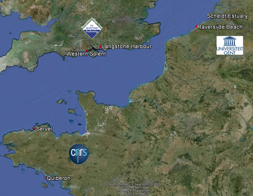 This map shows the locations of the partner organisations and the areas selected for archaeological fieldwork
Areas of the coastline which have archaeological or palaeoenvironmental information that can help tell the story of past change were identified i.e. monuments, fish traps, shipwrecks or submerged landscapes. This information was obtained from local, regional and national sources. The records were ranked using three key criteria, in addition to two further ‘non-scoring’ criteria. The ranking assessed the attributes of all types of sites, finds and deposits, to gauge their ability to provide information relating to processes or causes of coastal change. The results highlighted those sites with the most potential to aid coastal management strategies. For more information about the ranking methodology see the Guide and Technical Report available from the downloads page.